Where in Selkirk did monks begin building abbey?


The reason we know so little about Selkirk Abbey was that it never really got off the ground.
David’s charter establishing the abbey and allocating its lands and resources was produced around the year 1114, although almost certainly, as we shall see, there would have been an advance party from Tiron surveying and defining its basic requirements at least a year or two earlier.
Advertisement
Hide AdAdvertisement
Hide AdBy 1126 it was decided that Selkirk was not ‘suitable’ and the monks of Tiron moved to Kelso to establish their abbey there.
Although, from the time of its inception to the withdrawal to Kelso was not much more than 15 years, it is possible to establish where the monks of Tiron started their venture and why they needed to abandon the work they already had carried out to build Selkirk Abbey.
Although we know it was in the vicinity of Selkirk, the Abbey’s exact location has been contested, but plans and records exist which show us where the monks did intend to build their abbey.
One of Scotland’s oldest surviving written records, David’s charter of c1114, gives a detailed description of the lands given to the monks to build and support the Abbey.
Advertisement
Hide AdAdvertisement
Hide AdR.P. Hardie in ‘Roads of Medieval Lauderdale’ made a detailed and credible analysis of the description of the Selkirk lands gifted to the Abbey, the Selkirk-Abbatis.
The northern boundary was the stream which ran down from the ‘Crossinemara’ and into the Tweed. Hardie and Professor Barrow suggest ‘Crossinmera’ or ‘Crossanesmer’ refers to the land around Cauldshields and Faldonside Lochs.
The south boundary is the stream that runs down from the hills to the Yarrow, now known at Selkirk, as the Ettrick.
Hardie makes a reasonable argument that this stream refers to what is now known as the Batts Burn. It has been suggested, not without challenge, that the name Batts is derived from its association with ’Selkirk-Abbatis’.
Advertisement
Hide AdAdvertisement
Hide AdHowever, the really intriguing evidence from the charter, and the key to the mystery of where the Selkirk Abbey was intended to be, is the inclusion in the charter of a ‘particula terra’, beyond the stream, a small portion of land between the Yarrow and the road that ran from Selkirk castle to the abbey.
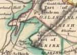
Convincing evidence of where this particular piece of land was can be found in 19th century Ordnance Survey, and earlier, maps depicting the Parish of Galashiels.
Parishes have played an important part in Scotland’s social and cultural history and defining them accurately was important. The parish you lived in decided which church you payed your teind or taxes to.
In the 13th century, the Scottish parish boundaries were defined and have since remained largely the same.
Advertisement
Hide AdAdvertisement
Hide AdThe OS 25 inch maps of 1863 for Selkirk and Roxburgh show a narrow strip of land extending from the direction of the Batts Burn south towards Selkirk and stopping at the Shaw Burn. This strip of land is almost certainly the ‘particular terra’ included in the charter, land belonging to Selkirk, then Kelso Abbeys; becoming part of Roxburghshire; and subsequently Lindean then Galashiels Parish.
The strip no longer immediately adjoins the river, but the river may well have deviated slightly in the intervening 700-plus years. This narrow strip of land, specifically included in the charter, a strange and puzzling offshoot from the main body of Abbey land, must have been required by the monks for a purpose.
The following extract from Richard Fawcett writing in ’Scottish Abbeys and Priories’ provides the likely answer.
“Much depended on the availability and position of a water supply to a monastery because it was quickly appreciated that an enclosed community had to have a dependable source of water for drinking, preparing food, ensuring certain basic standards of hygiene and for carrying away waste.”
Advertisement
Hide AdAdvertisement
Hide AdWe don’t have to look far down the Tweed for support of Fawcett’s claim that a water supply was essential for an abbey. At Melrose, just above the cauld, a lade or great drain runs off to the Abbey.
At Dryburgh, again running from the Cauld Pool, the lade runs off to service the Abbey. Kelso has a cauld and although urban development has obliterated where a lade might have been, Hogarth’s Mill shows the almost certain presence of a lade up river from the Abbey.
● In the next article, Frank looks at why the monks eventually moved to Kelso.