History set in stone, found in a forest near Galashiels


Mark Nicol has been showcasing the area’s historic landmarks and natural beauty through his Facebook page Discover Scottish Borders for several years.
But his latest find – a set of cup-marked stones on a hill close to Galashiels – has excited him more than any other.
Advertisement
Hide AdAdvertisement
Hide AdHe explained: “I received an intriguing email from my cousin Martin Pringle, who along with his pal Dave Smith had found some stones he thought I should look at.
“I looked at where he said they were on an old map, and was astounded to see that this area had once been called Picts’ Hill. Other than on this map, there was no reference to this I can find anywhere else. I had to have a look.”
In previous videos, Mark had shown evidence of a Pictish ditch called the Catrail, and of three brochs, or forts, situated around Galashiels, including at Bow Castle and Torwoodlee.
The reason he was so excited about this site in Ladhope Moor, was that it could have been the missing link that tied all the others together.
Advertisement
Hide AdAdvertisement
Hide AdIn his videos, Mark uses a mix of pieces to camera, long shots and drone shots.
Arriving at the forested area, Mark sent up his drone to check out the layout and marvels: “There are fantastic views here over the countryside, and there is a circular clearing at the top of the hill which could denote some sort of fort or broch.
Later, after wading through potentially snake-infested thigh-deep heather and crawling in some parts on hands and knees through the thick forested area, Mark talked of how little we know of the Picts in the south of Scotland.
He said: “According to history, the Picts were the wild men of the north of Scotland.
Advertisement
Hide AdAdvertisement
Hide Ad“But there are lots of sources, including the writing of St Columba of Iona, that refer to the southern Picts.
“I think the southern Picts were the wild men of the southern uplands – the Selgovae tribe.
“They probably had contact and connections with the Picts from the north of Hadrian’s Wall, they probably had very strong allegiances and alliances throughout their communities.”
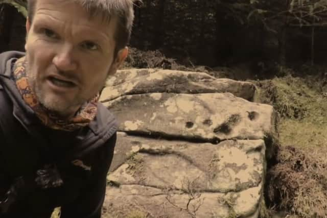
Then, Mark finds what he has been looking for – a series of large boulders with decorative, perfectly round holes – known as cupmarks.
Advertisement
Hide AdAdvertisement
Hide AdHe tells his viewers: “I think these are definitely cup marks here – they are too circular to be natural and I think there would be more of them if it was natural.
“And on this hill, it’s difficult to imagine this circle being formed out of acid rain or anything like that.
“There are so many of these large stones and I think a lot of them are man-made, and used for some purpose by man.
“This stone is an absolute gem buried deep in an old conifer forest.
Advertisement
Hide AdAdvertisement
Hide Ad“To me, this hill was a centre of population for the Picts – otherwise, why on earth would it have been called Picts’ Hill?
“We could potentially be re-writing the entire historical map of Galashiels and the Scottish Borders.”
He again sent up his drone, and it showed that the site was very close, “most likely within a visual line”, to Torwoodlee Broch.
He adds: “Someone discovered a road near here in 1984 through using aerial photography, and identified it as a Roman road, but it was never confirmed as such.
Advertisement
Hide AdAdvertisement
Hide Ad“I think it was not Roman, but that it was a native road, or a ditch like the Catrail. No Roman road could have existed beyond Pictish lines.
“We are also sitting here just opposite the Eildon hills. Were the Selgovae keeping an eye on the Romans from here? I think they were.”
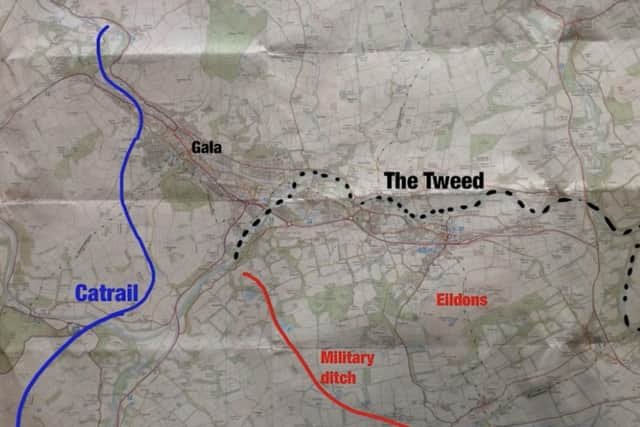
Since the film was made, Mark checked the area and where it stood in history.
And he came up with a map, which is quite stunning, in that it looks just like two front lines in the First World War, with the Catrail ditch on one side and a Roman military road on the other.
Advertisement
Hide AdAdvertisement
Hide AdGalashiels and the so-called Picts’ Hill lie in no-man’s land.
He told us: “It’s like a complete stand-off. All along both of these lines are forts ... the largest being at Rink Farm, between Selkirk and Galashiels.
“One of the best vantage points to see it is at the top of Cauldshiels Hill, where there was another fort.
“You can see the Catrail, the Rink fort. You can almost feel the tension when you are standing there ... the hairs stand up on the back of your neck and you can just about taste the history.
Advertisement
Hide AdAdvertisement
Hide Ad“Many people think the history of Galashiels begins with the industrial revolution, or perhaps a bit further back with the story of the Raid Stane.
“But long before that, it was a really important place.”
Since making the video, Mark says he has been contacted by several interested people.
He said: “There has been some debate about the stones, and the possibility that they could be even older, perhaps Bronze Age.
“Either way, I still believe the Picts would have had a community there. I can see no other reason for it to be called Picts’ Hill.”